Mahtam Population of Punjab According to the 1901 Census

In this, my seventh post on the distribution of tribes gazetted as agriculturalist, according to the 1901 Census of India will look at the Mahtam. In 1901, the total Mahtam population was 82,825, which was 0.3% of the population of undivided Punjab. Like many Punjab castes, the Mahtam were found as followers of all three religions of the Punjab, but with a clear Hindu majority of 48,586 (59%), followed by Sikhs at 19,183 (23%) and Muslims numbering 15,056 (18%). By 1931, the last census that counted caste, the Mahtam population had fallen to 65,210. Like many castes connected with agriculture, the Mahtam had been converting to Sikhism, in 1931 Sikhs now numbered 36,367 (56%), while Hindus had dropped to 15,482 (24%), while Muslims numbered 13,361 (20%), about the same percentage wise. The Sikh Mahtam now prefer the self-designation Rai Sikh.

The Mahtam were found mainly along the banks of the Sutlej and Ravi, in districts such as Firuzpur, Montgomery and princely state of Bahawalpur. In this region, they numbered 35,514, about 43% of the total population. They were found in three of the Divisions, which Punjab was divided in 1901, namely Lahore, Jalandhar and Multan, with no presence in the north-west (Rawalpindi Division) or south-east (Ambala Division). The largest number of Mahtam were in Firuzpur, home to 17% of their population, followed by Montgomery at 15%, Lahore at 12%, Bahawalpur State 12% and Hoshiarpur at 12%. About two-third of the Mahtam population was found in territory that went to Pakistan, as such they were one of the communities that suffered on account of the division of Punjab.
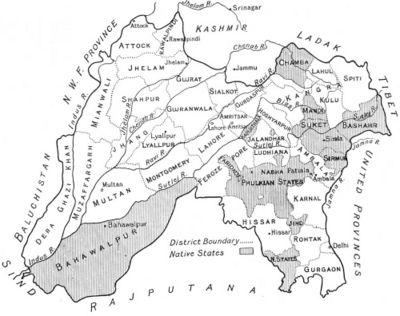
Punjab - FIBIwiki

Map of Punjab 1911

Their population as percentage of the total district population was as such:

Lahore Division

Montgomery 3%

Lahore 1%

Amritsar 0.17%

The total Mahtam population in the division was 24,161, which was about 29% of the total population. In Montgomery, they made 3% of the total population, and this district was one of the main centres of the caste. In terms of religion, Hindus were 11,934 (49%), Sikhs were 7,048 (29%) and Muslims were 5,179 (22%) in the Division.

Jallandhar Division

Firuzpur 1.4%

Hoshiarpur 1%

Jalandhar 0.24%

The total Mahtam population in the Division, including Kapurthala State, was 29,418, about 36% of the total Mahtam population. In terms of religion, Hindus were 18,697 (64%), Sikhs were 7,731 (26%) and Muslims were 2,990 (10%).

Multan Division

Bahawlpur State 1.4%

Muzaffargarh 1.1%

Chenab Colony

Multan 0.7%

Dera Ghazi Khan 0.7%

The total Mahtam population in this Division, including the Bahawalpur State, was 29,206, which was 35% of the total Mahtam population. In terms of religion, Hindus were 18,006 (62%), Muslims were 7,021 (24%) and Sikhs were 4,179 (14%).

District

Hindu

Sikh

Muslim

Total

Firuzpur

10,067 2,326 1,335 13,728
Montgomery 6,793 4,628 757 12,178
Lahore 3,279 2,184 4,422 9,885
Bahawalpur State 6,943 1,478 1,419 9,840
Hoshiarpur 6,500 3,013 14 9,527
Chenab Colony 3,774 2,701 12 6,487
Multan 1,869 3,256 5,125
Muzaffargarh 4,139 353 4,492
Kapurthala 1,365 1,066 1,172 3,603
Dera Ghazi Khan 1,281 1,981 3,262
Jalandhar 765 1,326 141 2,232
Amritsar 1,603 142 1,745
Sialkot 259 94 353
Faridkot 218 218
Ludhiana  110 110

Other Districts


 40

Total

 48,586

 19,183

 15,056

82,825


Meo and Khanzada Population According to 1901 Census of Punjab, Rajputana and the United Provinces

This is seventh post looking at the distribution of communities, namely the Khanzada and Meo, that were gazetted as agriculturalist in census of 1901 in the Punjab province. In this post, I will also look at the distribution of both communities in Rajputana and the United Provinces as well. Both groups were entirely Muslim. The Meo and Khanzada were concentrated in the Mewat region, in what is now south east Haryana and north east Rajasthan and claimed a Rajput status. Both groups claimed a similar origin from the Jadaun clan of Rajputs. The Meo and Khanzada were also found in Alwar and Bharatpur states in what was then the Rajputana Agency. In UP, the Meo were found largely in two regions, Rohilkhand, and the Doab region of western UP. Most of the Meo in UP were called themselves Mewati. The total Meo population in 1901 was 374,923, of which 147,198 (39%) were found in Punjab, 168,596 (45%) were found Rajputana (modern Rajasthan) and the remainder 59,129 (16%) were found in UP. In Punjab in 1901, Meo formed 0.7% of the total population of undivided Punjab, and 1.4% of the total Muslim population. They were the 18th largest Muslim caste in the province. The 1931 Census, the last that counted caste, the Meo population in Punjab had fallen to 133,091, and in Delhi which was now a seperate province, the Meo population was 5,259. The 1931 Census did not count the Khanzadas.

I would also ask the leader to look at my post on the Khanzadas to get some background information on the tribe.

1947AG.jpg

Map of Rajputana Agency: Source Wikipedia

Meo of Punjab

Most of the Meo population was concentrated as I have said in the introduction in the Mewat region, roughly the eastern portion of Gurgaon, and southern bits of Delhi. Outside these areas in Hissar and Karnal, there were a few isolated villages of the Meo. In 1901, this region was home to 137,028 Meo, which 93% of their total population in Punjab. In Gurgaon, the Meo formed 17.3% of the total population of the district, and in Delhi 1.2% of the total population.

The Meo of Dera Ghazi Khan

The Meo of Dera Ghazi Khan had separated from the main body of the Meo through a migration in the 16th Century. Most of the Meo of this region considered themselves as Jat, and were Seraiki speaking. They had lost all contact with the main body of the Meo.

Meo Population of Punjab

District Population
Gurgaon 128,760
Delhi
8,268
Firuzpur 4,378
Jalandhar 1,385
Dera Ghazi Khan 880
Karnal 813
Ambala 580
Hissar 543
Other Districts 1,591
Total Population 147,198

Meo Population of Rajputana

District Population
 Alwar State  113,154
Bharatpur State
51,546
 Kotah State  1,072
Marwar (Jodhpur State) 1,000
 Jaipur State 654
 Mewar (Udaipur State)  559
 Tonk  State  208
 Jhalawar 125
 Other States and Agencies 278
Total Population 168,596

Meo Population of the United Provinces

District Population
Bulandshahr 9,840
Bareilly 9,374
Rampur State 7,356
Aligarh 6,557
Meerut 5,184
Mathura 3,813
Pilibhit 3,262
Moradabad 2,513
Nainital 2,106
Etah 1,793
Lakhimpur Kheri 1,217
Badaun 1,081
Agra 873
Muzaffarnagar 779
Etawah 603
Shahjahanpur 534
Lucknow 418
Bijnor 365
Rae Bareli 355
Unao 253
Barabanki 220
Farrukhabad 216
Sahanranpur 210
Sultanpur 207
Total Population 59,129

Khanzada Population of Punjab

Almost all the Khanzada were found in Gurgaon, where in 1901, they owned nine villages near town of Nuh and to the north of Firozpur.

District Population
Gurgaon  3,901
Other Districts  70
Total Population  3,971

Khanzada Population of Rajputana

District Population
Alwar State  8,503
Bharatpur State 814
Jaipur State 97
Other States and Agencies 540
Total Population  9,954

Saini population of Punjab According to 1901 Census of India

This is my sixth post looking at the population of tribes gazetted as agriculture by the Punjab Land Alienation Act. This one will focus on the Saini community. Like the Mali looked in the previous post, the Saini were traditionally associated with marker gardening. In fact the boundary between the two castes is often blurred. In  1901, Saini numbered 126,671 and formed 0.5% of the population of undivided Punjab and were largely found in the sub-Himalyan regions such as Hoshiarpur and Ambala. Hoshiarpur was home to one-third of the Saini population, and if we add Kangra, Nalagarh, Gurdaspur and Ambala, the total increases to 70%. The remaining Saini were found mainly in Jalandhar (12.4%), parts of Patiala State (7%) that bordered Ludhiana, Kapurthala (2%) and Ludhiana (1%).

Like the Jats, the Saini were also in the process of converting to Sikhism, and it was more spectacular, by 1931, the total Saini population was 165,190, of which Sikhs were now 86,668, or 52% of the total, while Hindus now numbered 78,502.

In 1901, Punjab consisted of the following districts, divided into five divisions.

Punjab (British India): British Territory and Princely States
Division Districts in British Territory / Princely States
Rawalpindi Division
Lahore Division
Multan Division
Jullundur Division
Delhi Division
Total area, British Territory 97,209 square miles
Native States
Total area, Native States 36,532 square miles
Total area, Punjab 133,741 square miles


Punjab 1909.jpg

Map of Punjab in 1901

District wise, the majority of the Saini were found in the Jalandhar Division, and the Punjab Hill States. In terms of the percentage of the total population in each district of the Jalandhar Division, it was as follows:

Jalandhar Division

Hoshiarpur District 4.5%

Jalandhar 2%

Ludhiana 0.2%

Kangra 0.13%

The total Saini population in the Division, including Kapurthala State, was 65,930, which was 52% of the total Saini population. In terms of religion, the Hindu Saini population was 53,797 (82%), while the Sikh Saini population was 12,133 (18%). By the 1931 Census, the total Saini population was 60,445, of which Sikhs were 36,260 (60%) and Hindus were 24,185 (40%).

Ambala Division

Ambala 3%

Delhi 0.3%

The total Saini population in the Division, including the Kalsia State, was 29,284,  which was 23% of the total population. The Hindu population 27,026 (92%) and the Sikh population was 2,258 (8%). By the 1931 Census, the Saini population had almost doubled to 56,391, of which Hindus were 33,167 (59%) and Sikhs were 23,224 (41%).

Lahore Division

In Gurdaspur District in the Lahore Division, Saini were 2% of the total population, while there population in the rest of the Division was negligible. The total Saini population in the Lahore Division was 16,722, about 13% of the total Saini population. By the 1931 Census, the Saini population had increased to 21,410, of which Hindus were 11,044 (52%) Sikhs were 10,366 (48%). In the Lahore, the newly created Sheikhupura District, which had formed part of the Chenab Colony was now home to 4,450 Sikh Saini, mostly migrants from Hoshiarpur and Jalandhar.

Punjab States

Nalagarh State 4%

Patiala State 0.5%

Nalagarh, together with the Nahan State, in the Hill States gave a Saini population of 2,802. In the Patiala State, the total population was 9,055, of which Hindus were 6,321 (70%) and Sikhs were 2,734 (30%). In 1931 the total Saini population was 10,952, of which Sikhs were 7,923 (72%) and Hindus were 3,029 (28%).

District / State Hindu Sikh Total
Hoshiarpur 38,700 6,585 45,285
Ambala 23,435 2,213 25,648
Jalandhar 10,473 5,256 15,729
Gurdaspur 12,745 2,799 15,544
Patiala State 6,321 2,734 9,055
Chenab Colony (Lyallpur District) 2,017 489 2,506
Kapurthala State 2,180 70 2,250
Delhi 2,213 2,213
Nalagarh State 2,044 2,044
Kalsia State 1,378 45 1,423
Ludhiana 1,299 131 1,430
Kangra 1,030 1,030
Sialkot 867 867
Nahan State 758 758
Firozpur 115 91 206
Amritsar 147 26 173
Lahore 138 138
Other Districts 372
Total Population 106,006 20,665 126,671

Mali population of Punjab according to the 1901 Census of India

This is my fifth post that gives the distribution of caste gazetted as agricultural under the 1901 Census of Punjab, namely the Mali. In 1901, the Mali population was 112,916, about 0.4% of the total Punjab population, and was almost entirely Hindu. In the 1911 Census, where they numbered 103,642, of which Hindus were 101,565 (98%), while Sikhs were 1,122 and Muslims were 955. By 1931, the last census that counted caste, the Mali population had dropped 85,758, of which Hindus were 71,846 (84%), and Muslims were 13,912 (16%). The increase in Muslims is difficult to explain, but almost of all these were in Rawalpindi Division (11,864), and I suspect these groups had called themselves Malyar in earlier censuses, and with this category was deleted for the 1931 census, most had registered themselves as Mali.

The Mali are a caste of gardeners and vegetable-growers, with the word mali being derived from the Sanskrit mala, meaning garland. In my earlier posts, I have looked at castes who were largely Muslim, but the Mali were largely Hindu (almost 99%), and found mainly in the south east of Punjab (about 98%), the present day of Haryana. In terms of geographical distribution, the Maliar whose occupation specialization was the same as the Mali, but were Muslim, were found in the North west of colonial Punjab, namely the Pothohar region. It is likely in the Muslim dominated north west, most Mali had converted to Islam, and formed the Maliar caste. While in the South East, namely Haryana, where the Hindu faith dominated, most Mali had remained Hindu. In the central and south western districts, the Mali were absent, their traditional occupation either taken by the Muslim Arain or Hindu/Sikh Saini. In terms of distribution by district, 23% were found in Karnal, 21% in Ambala, 12% in Hisar, 11% in Delhi, 10% in Gurgaon and 8% in Rohtak. The Mali in Patiala and Nabha state were also found in territory that is now in Haryana. In Punjab proper, the Mali population was negligible.  and Sikh agriculturalist, who were said to be of Mali origin. I would also ask the reader to look at my post on the Saini, who were a community of Hindu and Sikh agriculturalist, who were said to be of Mali origin.

Haryana in 1901

In 1901, Punjab consisted of the following districts, divided into five divisions.

Punjab (British India): British Territory and Princely States
Division Districts in British Territory / Princely States
Rawalpindi Division
Lahore Division
Multan Division
Jullundur Division
Delhi Division
Total area, British Territory 97,209 square miles
Native States
Total area, Native States 36,532 square miles
Total area, Punjab 133,741 square miles

Ambala Division

Ambala 3%

Karnal 3%

Hisar 2%

Delhi 2%

Gurgaon 2%

98,089 Malis, about 87%, lived in the Ambala Division (mainly now Haryana), including the states of Kalsia (2%) and Pataudi (3%), whose territory lay entirely in this region. 570 were Sikhs and 105 were Muslims, the rest were all Hindu.

Phulkian States

Jind State 2%

Patiala State 0.5%

Jind State 0.2%

13,236 (12%) Mali were found in the Phulkian States, of which 106 were Sikh, and were just 10 Muslims.

Outside these two regions, the Mali population was negligible.

District

Hindu

Sikh

Muslim

Total

 Karnal

25,328

504

39
 25,871

 Ambala

24,095

66

15

24,176

 Hisar

13,068


13,068

 Delhi

 12,886


 51

 12,937

 Gurgaon

 10,884


10,884

 Rohtak

9,137


  9,137

 Patiala State

8,248

41


8,289


 Jind State

 4,423

65

10

4,498

Kalsia State

 1,311


1,311

Pataudi State 705     705
Nahan State 548  86 634
Nabha State 449 449
Firuzpur  201  19  220
Lahore  70  32  102

Other Districts

470 

 3

 168

 641

Total

111,823


799


294


112,916


Baghban and Malyar/Maliar Population of Punjab and the North West Frontier Province According to the 1901 Census of India

In this fourth post on the distribution of communities, I will look at two related communities, the Baghban and Malyar, sometimes spelt Maliar. Both were found largely in the Pothohar plateau, and neighbouring areas of Khyber Pakhtunkhwa, such as the Peshawar valley and the Hazara region. In terms of geographic distribution, they have much in common with the Awans, whose distribution I have looked at in a previous post. In 1901, the total Malyar population in Punjab was 81,093, which about 0.3% of the total population of undivided Punjab, and about 0.7% of the total Muslim population.In the North West Frontier Province, the Malyar population was 27,167, which was about 2% of the total population.

The term Baghban or sometimes pronounced Baghwan, is simply the Farsi equivalent of the Hindi word Mali meaning a ‘gardener,’ and commonly used as equivalent to Arain in the Western Punjab. According to Rose, the colonial British ethnologist:

Baghbans do not form a caste and the term is merely equivalent to Mali, Maliar, etc.

There is some confusion as to whether the Baghban and Maliar are distinct communities. In Peshawar, the Maliar and Baghban do seem to be distinct communities. But in other parts, the two terms are used interchangebly. It is also likely that Baghban of Patiala State were really members of the Arian caste. I would ask the reader to look at my post on the Maliar.

Writing in the 1911 Census report, Pandit Harkishan Kaul wrote the following about the Maliar:

MALIARS are almost all Musalman there being only 8 Hindus and 2 Sikhs; and have been returnod mainly from the Rawalpindi Division. They are cultivators and gardeners and are the same as the Mali or Baghban. There is little difference in the western districts between Maliar and Arain.

Indeed after 1911 census, Maliar were simply counted as Arain, although many Maliar also registered themselves as Awans or Janjuas.

Baghban Population of Punjab

District Muslim Hindu Total
Rawalpindi 502  141 643
Patiala State
397 397
Gujrat
207
  207
Mianwali
189   189
 Other Districts 257  50 307
Total Population 1,552 191 1,743

Baghban Population of North West Frontier Province

District Population
Peshawar  9,427
Bannu  2,155
Other Districts  289
Total Population  11,871

Malyar in Population Punjab

The Malyar were found entirely in the Rawalpindi Division, and in terms of percentage of the total population, in Rawalpindi District, the Malyar were 5% of the total population, in Jhelum 5% and in Shahpur 0.5%. They were also entirely Muslims.

District Population
Rawalpindi  50,125
Jhelum  28,371
Shahpur  2,651
Total Population  81,093 

Malyar in NWFP

In the NWFP, Malyar were 5% of the total population in Hazara, and 3% in Peshawer.

District Population
Peshawar  18,319
Hazara  7,770
Kohat  1,078
Total Population  27,167

Awan Population of Punjab and the North West Frontier Province according to the 1901 Census

This is my third post, looking at the population distribution according to the 1901 Census of Punjab. In this post, I look at the Awan caste, who unlike the castes looked in previous posts such as the Dogar and Kamboh, is entirely Muslim. In 1901, the Awan population was 421,112, which was 2% of the total population of undivided Punjab, and 4% of the total Muslim population. The Awan were the seventh largest Muslim group in Punjab in terms of population. By the 1931 census, the last that counted caste, the Awan population had risen to 539,242.

I will ask to the reader to look at my posts on the Kamboh, to give some background as geographical spread of Colonial Punjab. In addition, for completeness’s sake, I would ask you to look at my posts on the 1931 Census of Hazara, as well my the post on the Budhal, who are sub-group of the Awans, to get some background information on the caste. This post will also look at their distributions according to the 1901 Census of the of the North West Frontier Province of Pakistan. In 1901, the Awan population in the NWFP was 241,006, which 11% of the total population.

Map of Punjab 1911

In 1901, Punjab consisted of the following districts, divided into five divisions.

Rawalpindi Division
Lahore Division
Multan Division
Jullundur Division
Ambala Division

Awan Groups in Punjab

In terms of distribution, about two-thirds of the Awans lived in the Pothohar plateau, and the Salt Range mountains, which were located just below the plateau. The Awan population of the North West Frontier Province were culturally close to the Awan of the Pothohar. Both spoke related languages, the Hindko and Pothohari languages. In terms of distributions, 33% were found in Rawalpindi, in what was then Attock tehsil, 24% in Jhelum District, 13% in Shahpur District, 6% in Mianwali and 4% in Gujrat. All in all 80% of the Awan population was found in what was then Rawalpindi division.

A second cluster of Awans was found in the Lahore and Jalandhar divisions, territory that lies partly in Indian Punjab, and partly in Pakistani Punjab. The Awan of Sialkot, Gujranwala and Lahore were culturally similar to the East Punjab Awans. There were Awankari, or Awan inhabited territories in Ludhiana, Hoshiarpur, Jalandhar and Kapurthala state, all teritories now located in Indian Punjab. These Awans spoke standard Punjabi, and often used the surname Alavi. In terms of distribution, 6% were found in Sialkot, 3% in Hoshiarpur, 3% in Jalandhar, 1% in Ludhiana, 1% in Lahore, 0.4% in Amritsar, 0.4% in Gujranwala, and 0.3% in Gurdaspur. In total, about 15% of the Awans were found in this region.

The Awan of Mianwali spoke an intermediate dialect between Hindko and Seraiki. They were connected with the third cluster of Awans, those of Bannu and Dera Ismail Khan, and the southern Punjab districts of Dera Ghazi Khan, Muzaffargarh, Multan and the Bahawalpur State. These Awans spoke the Seraiki langage. In terms of distribution, 2% were found in Multan, 1% in Bahawalpur State, 0.8% in Dera Ghazi Khan and 0.8% in Muzaffargarh.

Percentage of Awan population in each district / State

In terms of the total percentage of district population, they were as follows:

Rawalpindi Division

Jhelum District 17%

Rawalpindi District 15%

Shahpur District 11%

Mianwali District 6%

Gujrat District 2%

The Awan population of the division was 334,077, which was about 80% of total Awan population.

Lahore Division

Sialkot District 2%

Montgomery District 0.4%

Lahore District 0.3%

Amritsar District 0.2%

Gurdaspur District 0.1%

Gujranwala District 0.1%

The total Awan population in this division was 33,792, which was 8% of the total Awan population.

Jalandhar Division

Hoshiarpur District 1.4%

Jalandhar District 1.4%

Ludhiana District 1%

Firuzpur District 0.05%

The total Awan population was 31,555 in the division, including Kapurthala State, which was 7% of the total Awan population.

Multan Division

Multan District 1%

Jhang District 0.8%

Muzaffargarh District 0.8%

Dera Ghazi Khan District 0.7%

Chenab Colony 0.4%

The total population in the division, including Bahawalpur State was 23,990, and was home to 5% of the Awan population in 1901.

Awan Population of Punjab

District Population
Rawalpindi 140,835
Jhelum 99,542
Shahpur 55,387
Sialkot 24,459
Mianwali 23,449
Gujrat 14,864
Hoshiarpur 13,652
Jalandhar 12,350
Multan 6,600
Bahawalpur 4,815
Ludhiana 4,580
Lahore 3,887
Dera Ghazi Khan 3,442
Muzaffargarh 3,232
Chenab Colony 3,001
Jhang 2,900
Montgomery 1,737
Amritsar 1,683
Gujranwala 1,018
Gurdaspur 1,008
Firuzpur 490
Kapurthala 483
Ambala 193
Total Population 421,112

Awans in the North West Frontier Province (NWFP)

In the NWFP, now known as Khyber Pakhtunkhwa, the Awans were concentrated in the Peshawar valleyHazara Region and the southern Seraik areas of Kohat, Bannu and Dera Ismail Khan.

District Population
Peshawer 111,339
Hazara 91,474
Kohat 22,358
Bannu 8,667
Dera Ismail Khan 6,396
Malakand, Dir, Swat, and Chitral Territories 512
 Other Districts
Total Population 241,006

Dogar Population of Punjab and the United Provinces according to 1901 Census

In this second post looking at 1901 Census, I will look at the distribution of the Dogar population. Like the Kamboh in my first post, the Dogar were gazetted as an agriculture tribe. However, the Dogar were almost entirely Muslim, out of a total population of 75,080, only 95 were Hindu, 9 were Sikh and 4 were Jain. In 1901, Dogar made about 0.3% of the total population of undivided Punjab, and 0.6% of the Muslim population. The Dogar were historically a pastoralist group, that by beginning of the 20th Century stretched from Sialkot in the west to Bulandshahr in the east.I wish to add that the Dogars have nothing to do with the Dogras, who are found largely in the Jammu region. Almost 70% of their territory went to India in 1947, leading to the migration of the Dogars to Pakistan. The only exception are the UP Dogars, who have largely remained in India. The last census to count the Dogars was the 1921 census, where they numbered 74,369.

Dogar Groups: The Ghaghar – Sutlej groups

The Dogar were found largely in the valley of the Sutlej, in Firuzpur, Faridkot State and the territory of Montgomery (present day Sahiwal and Okara) and the grasslands located between the Ghaghar and the Sutlej rivers, in what then the princely states of Nabha and Patiala and the Hissar territory, presently western Haryana. In terms of distribution, about 22% were found in Firuzpur, 15% in Patiala State, 10% in Hisar, 2% in Montgomery and 1% in Faridkot State. This region was home to half the Dogars lived, with a population of 37,889.

The Himalayan Group

A second cluster of Dogars were found along the Himalayas, stretching from Hoshiarpur to Sialkot. The Dogars of Lahore, Gujranwala, Jalandhar and Ludhiana were culturally related to the Himalayan group of Dogars. In terms of distribution, 10% were in Lahore, 7% in Hoshiarpur, 7% in Jalandhar, 7% in Amritsar, 4% in Gurdaspur, 4% in Sialkot and 4% in Ludhiana. This region was home to over 40% of the Dogars.

The Haryana and UP group

A final group was found in Karnal and Rohtak, and this group extended into the United Provinces, present day Uttar Pradesh. They differed from other Dogars in that they spoke Haryanwi, and not Punjabi. Karnal was home to the largest cluster. The Bulandshahr Dogars were migrants from Rohtak, mainly from the village of Parah in that district, settling in UP the mid 19th Century. Around 4%, numbering 2,890, of the remaining Dogar population was found in Haryana (excluding the Hisar Dogars), in Karnal, Ambala and Rohtak districts.

Dogar Distribution by District in Punjab

Punjab 1909.jpg

Map of Punjab 1911

Percentage of total Population by District / State

Firuzpur (2%)

Hisar (1%)

Patiala State (0.7%)

Lahore (0.7%)

Hoshiarpur (0.5%)

Jalandhar (0.5%)

Amritsar (0.4%)

Ludhiana (0.4%)

Montgomery (0.4%)

Gurdaspur (0.3%)

Sialkot (0.2%)

Karnal (0.2%)

District Population
Firuzpur 16,402
Patiala 11,243
Hissar 7,623
Lahore 7,503
Hoshiarpur 5,388
Jalandhar 4,409
Amritsar 4,128
Gurdaspur 2,615
Ludhiana 2,411
Sialkot 2,302
Karnal 2,064
Montgomery 1,675
Gujranwala 1,048
Faridkot 946
Ambala 386
Jind 230
Rohtak 210
Other Districts 34
Total Population 75,080

Dogar Population of the United Provinces

District Population
Bulandshahr 215
Total Population 215

Kamboh Population of Punjab According to the 1901 Census

This is the first of a number of blogs that will look at the results of 1901 Census of the Punjab, with reference to a particular caste. Its worth mentioning that in 1901, the Punjab included in Pakistan, the Punjab province and Islamabad, and in the India the states of Punjab, Haryana, Himachal and Delhi. I will start off by looking at the Kamboh community, which in total terms of the Punjab population in 1901, which was 24,754,737, numbered 174,061 (0.7%), which was not a large in population numbers. But as a gazetted agricultural tribe, under the  Punjab Land Alienation Act, 1900 in every district they lived in, were an important landowning group. I will ask the reader to read my post on the Muslim Kamboh of UP, which looks at their origin myths.

Like many Punjabi castes, the Kamboh were found in all three religions, namely Muslim (43%), Hindu (32%) and Sikh (25%), although Muslim Kambohs formed the largest sub-group. However, like other large agricultural castes like the Jat and Saini, the Kamboh were steadily converting from Hinduism to Sikhism. In 1931, the last census that counted caste, there population had increased to 239,582, of which Muslims were 100,081 (41%), a slight decrease percentage wise, but the Hindu Kamboh had fallen to 37,635 (16%) and Sikhs increased to 101,866 (43%).

One interesting fact is that the Kamboh religious affaliation did not follow that of a majority of the population they lived. In what is now Sahiwal and Okara (old Montgomery District), the majority of the Kamboh were Hindu, in a region that was predominantly Muslim. While in Patiala and Nabha, the modern areas of the Punjab and Haryana borderlands, the Kamboh were Muslim, in a largely Sikh region. They Kamboh were also linguistically and culturaly divided. In what now Haryana, the Kamboh spoke dialects of Haryanwi, and were connected with large Kamboh population of Saharanpur in UP. While through the central region of Punjab, stretching from Montgomery to Nabha, the Kamboh population was Punjabi speaking. A third group of Kambohs were those of Multan and Bahawalpur, entirely Muslim, and largely urban.

About 13% of the total Kamboh population was found in Lahore, 13% in the Patiala State, 13% in Montgomery, 10% in Amritsar, 10% in Kapurthala State, 10% in the Chenab Colony and 8% in Karnal.

Punjab 1909.jpg

Map of Punjab 1901 Source Wikipedia

In 1901, Punjab consisted of the following districts, divided into five divisions.

Rawalpindi Division
Lahore Division
Multan Division
Jullundur Division
Ambala Division

In terms of percentage of the total district population, they were as follow:

Lahore Division

Montgomery 5%

Lahore 2%

Amritsar 2%

Sialkot 0.2%

Gujranwala 0.2%

Gurdaspur 0.1%

Montgomery District was home to 13% of the total Kamboh population, and they made about 5% of the total population in the district. Overall, the Lahore Division was home to 40% of the total Kamboh population, and their population in the Division was 66,435, of which Muslims were 31,362 (47%), Hindus were 27,196 (40%) and Sikhs were 7,877 (13%).

Jalandhar Division (including Kapurthala and Malerkotla states)

Malerkotla State 7%

Kapurthala State 5%

Jalandhar 1%

Firozpur 1%

Ludhiana 0.2%

In the figures for the Jalandhar Division, I included Kapurthala and Malerkotla states, whose territories lay within the division. The division was home to 20% of the total Kamboh population in the province, with Malerkotla State almost 7% Kamboh. The total population in the division was 36,487, of which Sikhs were 17,979 (49%), Muslims were 15,123 (41%) and Hindus were 3,385 (10%).

Phulkian State

Nabha State 2%

Patiala State 1.4%

Jind State 0.5%

The Phulkian States, were three Sikh ruled states, which got their name from the Phulkian Dynasty, who were descended from the Sidhu Jats. Families of the dynasty ruled Patiala, Jind, and Nabha. They were home to 15% of the total Kamboh population, and numbered 25,929, of which Muslims were 17,746 (68%), Hindus were 5,883 (23%) and Sikhs were 2,300 (9%).

Ambala Division (including Kalsia State)

Karnal 2%

Ambala 1%

Kalsia State 1%

The Division, roughly comprising modern day Haryana, was home to 14% of the total Kamboh population in Punjab. These Kambohs, who spoke Haryanvi, were close to the Kamboh of western Uttar Pradesh. The total population was 23,865, of which Hindus were 17,888 (75%), Muslims were 3,427 (14%) and Sikhs were 2,550 (11%).

District

Muslim

Hindu

Sikh

Total


Lahore

 14,339

 6,227

 2,280  22,846


Patiala

 11,910

 5,819

 5,073

 22,802


Montgomery

 2,326

 19,507

 201  22,034


Amritsar

 11,494

 1,330

 4,907

 17,731


Kapurthala

 2,604

 1,289

 12,384

 16,277


Chenab Colony

 3,005

 1,880

 10,343  15,228


Karnal

 1,754

 11,945

 161

 13,860


Ambala

 1,673

 5,530

 2,123

 9,326


Firozpur

 5,204

 821

 327

 6,352

Jalandhar  191  1,040  5,086  6,317
Malerkotla  5,519  5,519
Nabha  4,559  48  20  4,627
Multan  1,947  1,947
Sialkot  1,746  1,746
Ludhiana  1,302  133  15  1,450
Jind  1,277  16  1,293
Gujranwala  744  19  471  1,234
Shahpur  957  957
Gurdaspur  713  94  18  825
Hoshiarpur   303  102  167   572
Kalsia  247  266  513
Bahawalpur  208  208
Hissar  166  166

Other Districts

 103

 84

 44

  231

Total

 73,878

 56,297

 43,886

 174,061